UOIT - like you've never seen it before
July 14, 2011
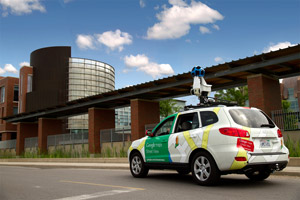
Students and visitors to UOIT will soon enjoy a unique online perspective of the university following a special visit to campus by a crew from Google Maps Street View. The Google team spent an entire day collecting new images of UOIT's expanding campus locations. The photos will be uploaded to Google's Street View map system in the coming months and should be available for multi-directional viewing online by December 2011.
UOIT's Communications and Marketing department invited Google to come to campus to capture our unique learning environment.
"Universities are large places with many roads, pathways and buildings that most people are not typically familiar with," said Chris Woods, web strategist, UOIT Communications and Marketing. "Google is working hard to add more data from Canadian university campuses to Street View, so we're pleased that they came to UOIT. Once these photos are online, the user-friendly viewing system will make it easier for UOIT visitors to find key locations and determine where they are going before they come to campus."
")
Armed with multiple cameras and computers on a sport utility vehicle (SUV) and a 200-kilogram manual tricycle (or trike), the Google team spent the bulk of its time collecting data at UOIT's north Oshawa location, which the university shares with Durham College. Google also took images of UOIT's downtown Oshawa location (61 Charles Street and the historic Regent Theatre) and also of Durham College's campus facilities in Whitby.
Using the latest in camera technology, the Google SUV features 15 lenses taking 360-degree photos while it moves. The car employs motion sensors to track its GPS position, has a hard drive to store the data collected and also features lasers to capture 3D data to determine distances within the Street View imagery. Google's trike camera system complements the SUV because the three-wheeler can be driven by one person into interesting places on campus not accessible by car (such as pathways, trails and sidewalks that are adjacent to major buildings).
About Ontario Tech University
A modern, forward-thinking university, Ontario Tech advances the discovery and application of knowledge to accelerate economic growth, regional development and social innovation. We inspire and equip our students and our graduates to make a positive impact in a tech-focused world. For us, it’s not only about developing the next tech breakthrough. Understanding and integrating the social and ethical implications of technology differentiates us as university. Learn more at ontariotechu.ca.
More news

Ontario Tech recognizes top high school students in second annual essay contest
HackHive brings students together to build practical AI solutions

Ontario Tech researcher’s public education sessions introduce community members to the world of AI

Ontario Tech University welcomes the Ontario government’s investment in post-secondary education
Ready for tomorrow’s careers.
We prepare our students for the fast-paced, ever-evolving world of technology.